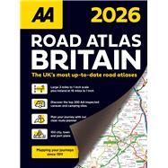
AA Road Atlas Britain 2026 Spiral
by Publishing, AABuy New
Rent Textbook
Used Textbook
We're Sorry
Sold Out
eTextbook
We're Sorry
Not Available
How Marketplace Works:
- This item is offered by an independent seller and not shipped from our warehouse
- Item details like edition and cover design may differ from our description; see seller's comments before ordering.
- Sellers much confirm and ship within two business days; otherwise, the order will be cancelled and refunded.
- Marketplace purchases cannot be returned to eCampus.com. Contact the seller directly for inquiries; if no response within two days, contact customer service.
- Additional shipping costs apply to Marketplace purchases. Review shipping costs at checkout.
Summary
*The UK’s most up-to-date road atlases*
Main Features:
• Up-to-date mapping from the experts at the AA
• Large 3.2 miles to 1 inch scale
• A4 format revised and updated for 2026
• 6 page clear route planner map
• District mapping of London, Birmingham, Glasgow, Manchester and Newcastle
Author Biography
An electronic version of this book is available through VitalSource.
This book is viewable on PC, Mac, iPhone, iPad, iPod Touch, and most smartphones.
By purchasing, you will be able to view this book online, as well as download it, for the chosen number of days.
Digital License
You are licensing a digital product for a set duration. Durations are set forth in the product description, with "Lifetime" typically meaning five (5) years of online access and permanent download to a supported device. All licenses are non-transferable.
More details can be found here.
A downloadable version of this book is available through the eCampus Reader or compatible Adobe readers.
Applications are available on iOS, Android, PC, Mac, and Windows Mobile platforms.
Please view the compatibility matrix prior to purchase.
